The Wings of Adventure: Flying with Courage and Dreams, Crossing the Numerous Obstacles of Adventure
The Wings of Adventure: Flying with Courage and Dreams, Crossing the Numerous Obstacles of Adventure The Wings of Adventure: Flying with Courage and Dreams, Crossing the Numerous Obstacles of Adventure
Cart(0)
Home Expedition Supplies Waterproof Maps
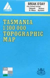
8514 Break O`Day Topographic Map (2nd Edition) by TasMap (1979)
  • DefaultTitle

$ 0.00

$ 10.00

Please select combo product attributes
The combo subtotal is $,SAVE$
Unavailable

Product Details

The 1:100 000 topographic map series from TasMap covers the Break O'Day area.

This map includes the following details:

  • Both man-made and natural features
  • Roads are symbolized to reflect their surface, accessibility and importance to the State network
  • Distances between major road intersections and the portrayal of selected addressed buildings aid vehicle navigation
  • All major reserved land and foot tracks are clearly defined
  • The shape of the ground is depicted by using a combination of contours (at a 20 metre vertical interval) and hillshading
  • Both forested and non-forested areas
You May Also Like
Cart
The Wings of Adventure: Flying with Courage and Dreams, Crossing the Numerous Obstacles of Adventure
Your cart is currently empty.